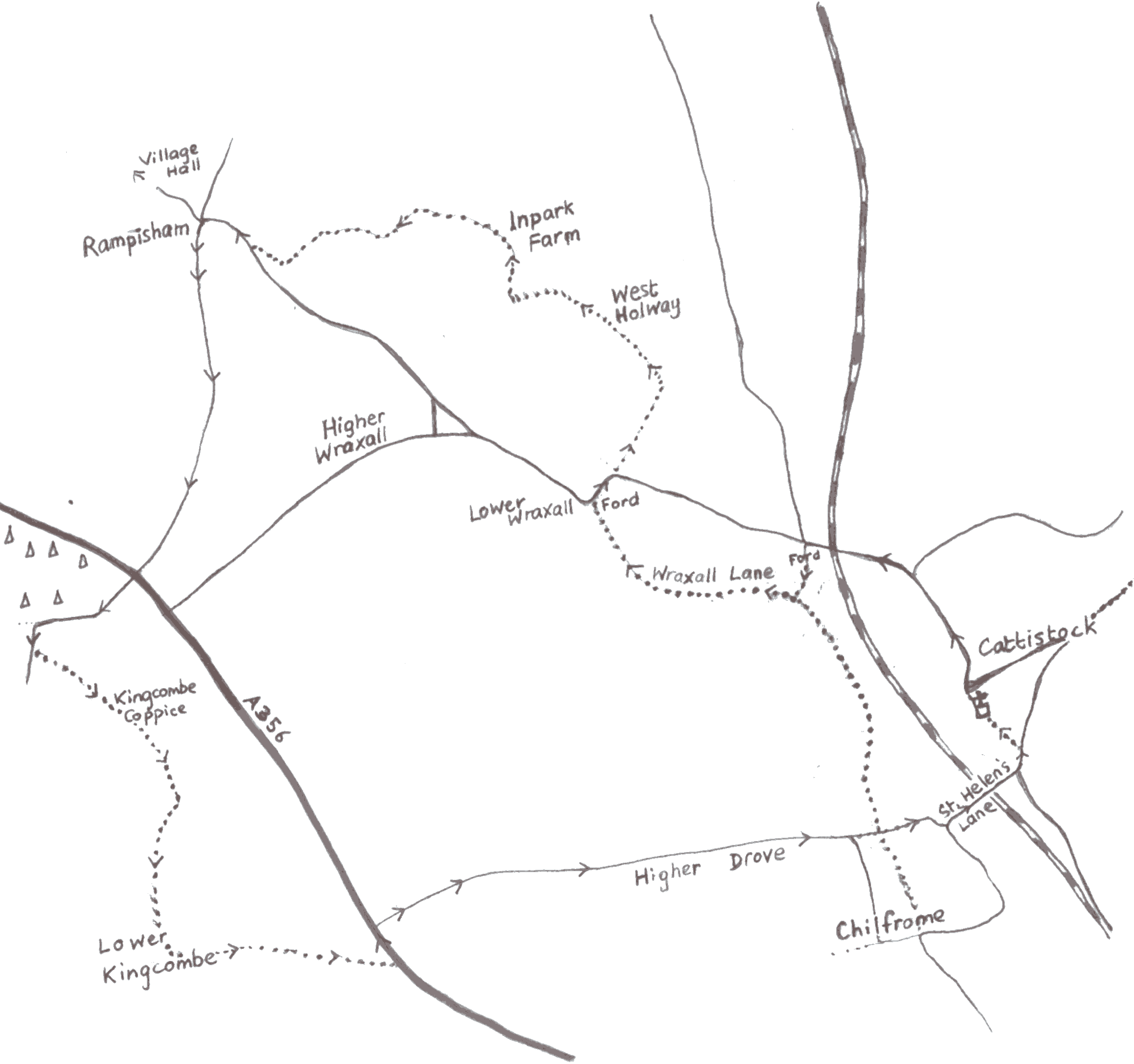
Walk 1. - Cattistock, Dorset, England

Distance : approximately 9 miles

How to get to the start : Approach from the A 37 (Dorchester to Yeovil), signed Cattistock.

O.S. Map: Explorer 117 or Landranger 194

This is a circular walk, mainly across fields (can be muddy in wet weather) or on lanes and tracks, but with a few quiet roads.


  1. With your back to the main entrance to the church in Cattistock village, head along the road northwards, passing the Post Office on your left. Keep walking through Sandhills, but opposite the turning to Evershot turn left to join a track (this can be very wet at times). At a T-junction of tracks turn right along Wraxall Lane and keep walking past South Wraxall Farm until you come out at the ford in Lower Wraxall.
  2. Turn right along the road. Shortly after the road bends to the right and before the house on the left, turn left through a gate and continue straight ahead. Ignore the gate straight in front of you. Instead turn right and through a gate leading into a field. Keeping the fence on your left (and ignoring 2 gates in it), continue to the field boundary. Here go through the gate facing you and then turn immediately left along a track.
  3. You pass through a second gate, go past some farm buildings on your right, then keep straight ahead through a third gate, which takes you along a lane between 2 hedges. The lane opens out into a field - keep the fence and hedge on your right.
  4. Pass through a gate in the corner of the field and follow the footpath sign (angled to the left) to the far corner of the next field. This can get very muddy! Pass through the gate and follow the footpath sign across the field. With the farm buildings ahead to your right, pass a clump of trees and look for a stile in the far left-hand corner. Cross over this stile. Then over a sleeper bridge and through a gate into the next field.
  5. Cross this field and head diagonally right to a stile tucked away in the far right-hand corner of the field. Cross this and a second stile and head towards the farm buildings (Rampisham church should be visible beyond and to the right). Just before the gate leading to the farm, turn left through a gate, stepping over an electric (?) fence first, and head diagonally right to a stile, crossing a stream on the way.
  6. Walk over the hill with gorse bushes to the right. At the start of the copse, turn left across a bridge (take care!). Keep the trees on your right and go up the hill to an opening on the right. Go through this opening and across the field to a stile in the far right-hand corner of the field. This will bring you out on to the road. Turn right along the road.
  7. When the road bears sharply right, turn left up the hill and past the church and walk for about a mile until you reach the main A356 road. Cross the road with caution and follow the road opposite, keeping the Rampisham masts on your right. When the road bears sharp left, ignore the footpath straight ahead and after about 75 yards turn left through a field gate. (From this point you will follow the Wessex Ridgeway until you leave Higher Drove).
  8. Cross the field and go through a gate, cross a meadow, following the valley round, and through a small gate into Kingcombe Coppice. Follow the path through the coppice, turning right when it meets a wider path. Go through yet another gate and across a field. After passing through the next gate you should come out on to a hollow lane. Continue along this lane for about half a mile until it comes out on to the road at the top of Lower Kingcombe village.
  9. Turn left along the road past some houses. When the road bears right, continue straight ahead along the muddy lane. At a junction of paths turn left and in 12 yards turn right and through a gate. Follow the direction of the arrow and aim for a solitary tree in the middle of the field. At the tree (and a post beside it) bear right and pass to the left of a clump of trees beside a ditch.
  10. Go through a gate and bear right through 2 fields (cut the corner of the first, go through a gap and continue in the same direction across the second). Through a gate and along a narrow path through some scrub. Come out and cross a field to a gate. Go through the gate and bear half left across a field to another gate in the far corner. Come out on to the main road (almost opposite telegraph pole no. 28!). Turn left and walk carefully along the road for about 200 yards.
  11. Turn right into Higher Drove (signed 'Lancombe Cottages') and walk along this road for about a mile and a half towards Chilfrome. Where the road turns sharp right, turn left on to a bridle way to come out on to Wraxall Lane. Cross straight over Wraxall Lane and through a gate into the field opposite. Keep to the right-hand side of the field and cross a stile into a second field. Continue along the right-hand edge and through a white gate, which brings you out on to St. Helen's Lane.
  12. Turn left and continue along the road and under the railway-bridge until you come to the Maiden Newton road. Turn left and go past the cricket ground. Shortly after the cricket field you turn left through a kissing-gate (marked by a footpath sign) and follow the path between 2 fields to a second kissing-gate. This leads you into Cattistock churchyard and from there back to the 'square'.


 MAP

  Back to walking